|

On eBay Now...
Original 1890 Antique Map IOWA Dubuque Council Bluffs Cedar Rapids Newton Boone For Sale

When you click on links to various merchants on this site and make a purchase, this can result in this site earning a commission. Affiliate programs and affiliations include, but are not limited to, the eBay Partner Network.

Original 1890 Antique Map IOWA Dubuque Council Bluffs Cedar Rapids Newton Boone:
$26.80
Original 134-year-old Antique Map of Iowa Drawn & Engraved by E.F. Fisk for the 1890 Edition of The People's Cyclopedia of Universal Knowledge: A Compendium of Invaluable Reference in all Departments of the Arts and Life; Illustrated with More than Five Thousand Engravings and Over One Hundred Color Maps of Each State, Principal City, and Territory of the United States, Continents, and Countries Across the Globe. Intricate Detail of County Boundaries, Cities, Towns, Railroads, along with Rivers, Lakes, and other Natural Landmarks. Fine Map for the Collector or Historian. Great for American History and Family Genealogy. Makes an Imaginative and Creative Gift. Easily Framed. Original Map Drawn & Engraved by E.F. Fisk for the 1890 Edition of The People's Cyclopedia of Universal Knowledge: A Compendium of Invaluable Reference in all Departments of the Arts and Life, the Whole Brought Down to the year 1890, with Pronunciation Conformed to Webster's Unabridged Dictionary, Illustrated with More than Five Thousand Engravings and Over One Hundred Color Maps of Each State, Principal City, & Territory of the United States, Continents, and Countries Across the Globe.NOT A REPRODUCTION.Edited by W.H. De Puy, A.M., D.D. and Assisted by a Corps of Special Contributors, Including: Thomas A. Edison, Inventor of the Telephone & Phonograph; John Clark Ridpath, Author of The History of The United States of America; A.G. Haywood, President Emory College, Oxford, Georgia; William F. Warren, President Boston University;Joseph Alden, President New York State School, Albany; Thomas Summers, Professor Vanderbilt University; and William Wells, Professor Union College. Engraved by E.F. Fisk. Published 1890 by Hunt & Eaton; New York and San Francisco; a Copy of the Title Page of Which is Included. Intricate Detail of County Boundaries, Cities, Towns, Railroads, along with Rivers, Lakes, and other Natural Landmarks. United States 1880 Census Population of Each County listed on Reverse. Fine Map for the Collector or Historian. Great for American History & Genealogy. Easily Framed. Dimensions:10.5"x13.5" Map is inExcellent/Very Goodcondition. No writings, marks, or tears. Mild foxing. Single fold as Issued. A Few of the Cities, Towns, Counties, Railroads, and Landmarks Shown on the Map Include:Belle Plaine, Newton, Grinnell, Decorah, Shenandoah, Clarinda, Waverly, Eagle Grove, Manchester, Albia, Pella, Hampton, Osage, Tipton, Denison, Stuart, Des Moines, Dubuque, Davenport, Sioux City, Burlington, Cedar Rapids, Council Bluffs, Slinton, Ottumwa, Keokuk, Muscatine, Marshalltown, Fort Dodge, Ft. Madison, Oskaloosa, Waterloo, Boone, Jefferson County, Marion County, Crawford County, Hamilton County, Guthrie County, Iowa City, Creston, Lyons, Mason City, Webster City, Le Mars, Independence, Fairfield, Charles City, Red Oak, Cedar Falls, Atlantic, Marion, Washington, Perry, Cherokee, Chariton, Missouri Valley, Charlton, Glenwood, Iowa Falls, Nevada, Eldora, Mystic, What Cheer, Eagle Grove, Knoxville, Waverly, Clarinda, Carroll, Winterset, Manchester, Spencer, Pella, Lake Mills, Beacon, Grand Junction, Northwood, Garner, Nora Springs, Adel, Corydon, Spirit Lake, Malvern, Cascade, Manson, Dunlap, Rockford, Columbus Junction, Mapleton, Lamont, Greene, Fayette, Wapello, Manning, Afton, Lamont, Sibley, Britt, New Sharon, Leon, Calmar, Toledo, Monticello, Osceola, Glenwood, Villisca, Marengo, Eldora, Lake City, Ames, Hamburg, Eldon, Waukon, West Union, Onawa, Rock Rapids, and many others. (If you are Interested if a particular city, town, family, or landmark is shown, email the name & vicinity and I will look to see if it is included on the map.) Imaginative & Creative Gift.
Some, to beautify their parlors, chambers, and studies . . . loveth, getteth, and useth, maps, charts, and geographical globes.
-John Dee, Advisor to Elizabeth I.

Original 1890 Antique Map TEXAS INDIAN TERRITORY Garland Waco Tyler Brownsville $52.00
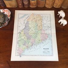
Original 1890 Antique Map MAINE Portland Lewiston Brewer Auburn Bangor Rockland $26.80

Original 1890 Antique Map IOWA Dubuque Council Bluffs Cedar Rapids Newton Boone $26.80
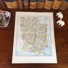
Original 1890 Antique Map LOUISIANA ARKANSAS MISSSISSIPPI Baton Rouge Vicksburg $26.80
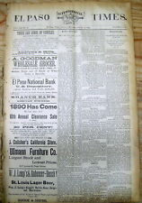
Lot of 5 original 1890 newspapers EL PASO Texas 135 years ago WILD WEST frontier $30.00
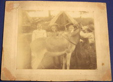
C. 1890, Black and White American Children, with a donkey, encampment setting $55.00
Original 1890 Antique Map ALABAMA Montgomery Florence Auburn Athens Oxford Selma $26.80

Original 1890 Antique Map OHIO Columbus Youngstown Parma Dublin Mason Kent Stow $26.80
|


