|

On eBay Now...
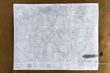
WW2 Bastogne map 32- Battle of the Bulge For Sale

When you click on links to various merchants on this site and make a purchase, this can result in this site earning a commission. Affiliate programs and affiliations include, but are not limited to, the eBay Partner Network.

WW2 Bastogne map 32- Battle of the Bulge:
$26.00
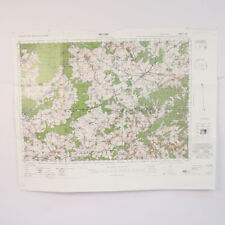
This listing is for 1reproduction \"Bastogne NE\"map in 1:25,000 scale. This map wouldhave been the most common from Division Headquarters all the way down toplatoon leaders, company commanders, and senior platoon/company NCO\'s during the defense of Bastognefor use in land navigation and tactical movements. NOTE: The \"labels\" featuring the divisional defenses (on the second picture in this listing) are for reference only and are not on the printed map you will receive. This map primarily shows the city of Bastogneas well as the surrounding areas to the east, south and west. As you can see on the second picture of thislistingthe southern halfof the defensive perimeter around Bastogne is featured on this mapincluding the 501st defensive sector to the east from Bizory to Marvie, the 326th/327th defensive sectorto the south from Marvie to Mande- St. Etienne, and a section of the 506th Defensive sector North or Luzery. The rest of the defensive perimeter can be seen on the St. Hubert SE map (not included in this listing). NOTE: This map of Bastogneand its \"sister map\" of St. Hubertare both GSGS series 1939 maps but the St. Hubert map is a later edition which was re configured bythe US war department to use the UTM grid system. What that means is the gridlines on the Bastogne NE map are running vertical and horizontally across the map where as on the St. Hubert SE map the gridlines are running slightlydiagonally across the map. If you take both maps and line them up to one another all the roads, villages, and terrain features line up perfectly but the grid squares and numbers do not correlate to each other. Please see the picture of the \"combined maps\" on this listing for further clarification. Keep in mind that geographicmapsused in World War Two were not being made in relation to the tactical environment of the battlefield. Most if not all cartographers (map makers) did not know where the D-Day invasion (or any other invasion) was going to take place so you often find that key objectives are split over several different maps. That being the case officers and NCO\'s often carried numerous maps not knowing if their tactical movement would keep them on one map or take them across several maps. Bulk orderdiscountsare available. Please message me for details. These reproductions are made from scans of theoriginal maps and maintain the same size, color, and scale ofthe originals. The grid squares maintain their original size and can be used accurately with modern or vintage protractor tools.They have been colorprinted on one side of 20LB engineering paper leaving the back of the map white. Whetherfolded and creased to fit in a pocket or mapcase for field use or kept flat tobe framed for staticdisplay these maps will make great additions to any collection. This listing is for 1 reproduction map only(see picture 1 in this listing). Any and all other items pictured in this listing are not included in this sale. Special note for international buyers (buyers outside the US): international shipping costs cover the postage for the order but maybe subject to customs fees unique to your country. Seller is not responsible for any additional postage or customs fees. These maps will be shipped in a 3\' wide cardboard tubesso that the maps remain flat and unfolded. However, beings that these maps are scans of originalssome of the wrinkles/folds of said originalmapswill be visible on the flat print of these reproductions. Please note,that like all paper items shipped in protective tubes, these maps may have small folds or imperfections around the edges, these are to be expected and are not considered \"damaged\" and are not eligible for returns.
WW2 Bastogne map 31- St. Hubert- Battle of the Bulge $26.00

WW2 Bastogne map 32- Battle of the Bulge $26.00
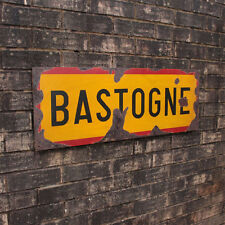
WW2 Bastogne Road Sign - Repro Vintage Style Army Military Belgian Steel Wall $67.18
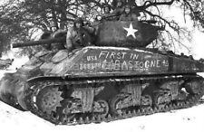
WW2 Picture Photo First in Bastogne written on M4A3E2 Jumbo Sherman Tank 0782 $5.90
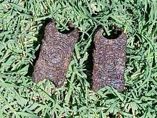
WW2 HISTORIC Battlefield Relic US Foxhole Find Bastogne/Bulge Lot $38.00
Replica Bastogne Reprint of a WW2 Combat Map used in "Battle of the Bulge" by... $17.12

WWII B&W Photo M4 Sherman Tank Bastogne Battle of Bulge 4th Armored WW2 / 3021 $6.49

WW2 WWII Photo US Army Sherman Tank 4th Armored First in Bastogne World War Two $6.49
|


