|

On eBay Now...
USGS EAST SHASTA COPPER ZINC DISTRICT, CALIFORNIA, HUGE 16 MAPS, 1961, REDDING For Sale

When you click on links to various merchants on this site and make a purchase, this can result in this site earning a commission. Affiliate programs and affiliations include, but are not limited to, the eBay Partner Network.

USGS EAST SHASTA COPPER ZINC DISTRICT, CALIFORNIA, HUGE 16 MAPS, 1961, REDDING:
$50.00
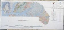
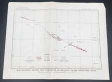
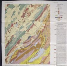
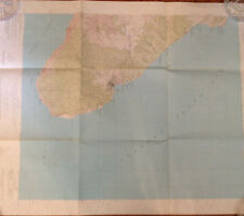
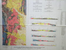
RARE ONE!! ONLY ONE I\'VE EVER HAD!! AMAZING MAPS AND HISTORY!! This is USGS Professional Paper 338, Geology and Ore Deposits of East Shasta Copper-ZInc District, Shasta County, California, Published in 1961, this is a very scarce item! This item comes complete withthe 107-page bookand all 16 of the original geologic maps, which come in a separate map case! This area was a significant mining district for many years. The geology covers the area around the southern and eastern parts of Lake Shasta. Most of the maps are color, and show the regional geology, the geology of specific mines, and cross sections and levelmapsof underground workings of some of the mines. This is a huge report I have never offered before and I have to say the maps are really nice. The largest map is about 50 inches wide! (photo #2) There is also a fantastic block diagram of one of the mines (#9), as well as lots of other interesting ones. Have a look through all the pictures. This area featured numerous mines, among which were: Bully Hill mine Afterthought mine Asher prospect Cook Prospect Cowboy City mine area Donkey mine and several others. All the formations of the area are described in detail, as well as the minerals found in the mines. About 26 minerals are mentioned in the text, including gold and silver in addition to numerous copper minerals, and sphalerite and galena. Covellite is noted as having been found at one of the mines. There is a wealth of information here, enough to keep you busy for a while going though it all. It makes for interesting reading, and the maps are great. It is so uncommon to find everything complete and together. Expert packing assured. Visit my store,Rockwiler Books and Minerals. I will continue to add items to my store, so check back frequently. ®
ROCKWILER
USGS EAST SHASTA COPPER ZINC DISTRICT, CALIFORNIA, HUGE 16 MAPS, 1961, REDDING $50.00
USGS West & East Greyrock Mine Known Vein Structure Map Silver Bow Montana MT $14.99
USGS NEWTON EAST NEW JERSEY GEOLOGIC MAP 1993 Spectacular Map, Lake Wawayanda $11.90
USGS geologic map Santa Catalina East, California t 1980 22x27 $12.50
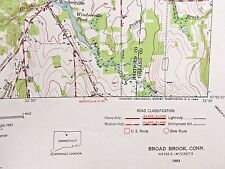
East Windsor CT BROAD BROOK CT TOPOGRAPHICAL MAP c1953 Connecticut River etc etc $27.50
ORLANDO EAST FLORIDA QUADRANGLE 7.5 MINUTE SERIES MAP TOPOGRAPHICAL 1956 USGS $8.99
USGS ORE DEPOSITS, EAST FLANK, ELKHORN MOUNTAINS, MONTANA MAPS NICE 1971 $18.00
1909 ANTIQUE HEMPSTEAD QUADRANGLE NEW YORK USGS TOPOGRAPHIC Topo Map $85.00
|


