|

On eBay Now...
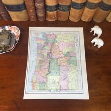
Original 1885 Antique Map WASHINGTON STATE OREGON Vancouver Kent Tigard Portland For Sale

When you click on links to various merchants on this site and make a purchase, this can result in this site earning a commission. Affiliate programs and affiliations include, but are not limited to, the eBay Partner Network.

Original 1885 Antique Map WASHINGTON STATE OREGON Vancouver Kent Tigard Portland:
$33.60
Original 139-year-old Antique Map of Washington and Oregon Drawn & Engraved by L.B. Folger for the 1885 Edition of The People's Cyclopedia of Universal Knowledge: A Compendium of Invaluable Reference in all Departments of the Arts and Life; Illustrated with More than Five Thousand Engravings and Over One Hundred Color Maps of Each State, Principal City, and Territory of the United States, Continents, and Countries Across the Globe. Intricate Detail of County Boundaries, Cities, Towns, Railroads, along with Rivers, Lakes, and other Natural Landmarks. Fine Map for the Collector or Historian. Great for American History and Family Genealogy. Makes an Imaginative and Creative Gift. Easily Framed. Original Map Drawn & Engraved by L.B. Folger for the 1885 Edition of The People's Cyclopedia of Universal Knowledge: A Compendium of Invaluable Reference in all Departments of the Arts and Life, the Whole Brought Down to the year 1885, with Pronunciation Conformed to Webster's Unabridged Dictionary, Illustrated with More than Five Thousand Engravings and Over One Hundred Color Maps of Each State, Principal City, & Territory of the United States, Continents, and Countries Across the Globe.NOT A REPRODUCTION.Edited by W.H. De Puy, A.M., D.D. and Assisted by a Corps of Special Contributors, Including: Thomas A. Edison, Inventor of the Telephone & Phonograph; John Clark Ridpath, Author of The History of The United States of America; A.G. Haywood, President Emory College, Oxford, Georgia; William F. Warren, President Boston University;Joseph Alden, President New York State School, Albany; Thomas Summers, Professor Vanderbilt University; and William Wells, Professor Union College. Engraved by E.F. Fisk. Published 1885 by Phillips & Hunt; New York and San Francisco, in Conjunction with Martin Garrison & Co., Boston and Toronto: 1885; a Copy of the Title Page of Which is Included. Intricate Detail of County Boundaries, Cities, Towns, Railroads, along with Rivers, Lakes, and other Natural Landmarks. United States 1880 Census Population of Each County listed on Reverse. Intricate Detail. Exceptional Color. Fine Map for the Collector or Historian.
Great for American History & Genealogy.
Easily Framed. Dimensions:10.5"x13.5" Map is inExcellent/Very Goodcondition. No writings, marks, or tears. Mild foxing. Single fold as Issued. A Few of the Cities, Towns, Counties, Railroads, and Landmarks Shown on the Map Include:WASHINGTON:Kent, Tacoma, Seattle, Olympia, Mt. St. Helens, Yakima City, Fort Simcoe, Selah, Orting, Franklin, Beaver, Clifton, Whatcom, Benton, Ainsworth, Moses Lake, Paha, Twin Wells, Walla Walla, Prescott, Norton, Block House, Fulda, Martins Bluff, Oakland, Cowlitz, Hayes, Grays Harbor, Destruction Island, Flattery Rocks, Puget Sound, Fort Madison, Elmo, Mason County, South Bend, Natchez, Island Rapids, White Bluff, Stanwood, Alderton Station, Orting, Cherry Valley, Montesano, Mt. Rainier, Park Place, Lowell, Tenino, Oakville, Little Pass, Martins Bluff, Goldendale, Norton, Cheney, Spokane Falls, Walker's Prairie, and many others.OREGON:Portland, Latham, Oakland, Oregon City, Molalla, Yuma, The Dalles, Columbus, Willow Forks, Bridge Creek, Warm Springs, Blue Mountain, Pendleton, Milton, Hawthorne, Helix, Cross Hollows, Bake Oven, Starkey, Mitchell, Parsley, Whitehall, Camp Warner, Lakeview, Tule Lake, Juniper, Christmas Lake, Diamond, Eugene, La Fayette, Aurora, Salem, Milwaukee, Clackamas, Sandy, New Era, Fox Valley, Jefferson, Jordan, Marion, Monmouth, Airlie, Summit, Toledo, Philomath, Corvallis, Tillamook, Silver Lake, and many others. (If you are Interested if a particular city, town, family, or landmark is shown, email the name & vicinity and I will look to see if it is included on the map.) Imaginative & Creative Gift.
Some, to beautify their parlors, chambers, and studies . . . loveth, getteth, and useth, maps, charts, and geographical globes.
-John Dee, Advisor to Elizabeth I.
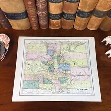
Original 1885 Antique Map COLORADO Boulder Pueblo Centennial Aurora Arvada Aspen $42.00
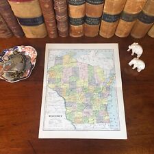
Original 1885 Antique Map WISCONSIN Madison Kenosha Waukesha Appleton Green Bay $42.00

Original 1885 Antique Map KENTUCKY TENNESSEE Lexington Nashville Knoxville Berea $42.00
Original 1885 Antique Map WASHINGTON STATE OREGON Vancouver Kent Tigard Portland $42.00

Nova Scotia - Original 1885 Railroad Map by Rand McNally. Antique $15.00

Original WWI German Decorated Infantry Soldier Death Card Johann Siegl 1885-1916 $4.99
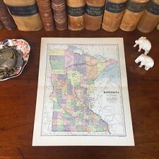
Original 1885 Antique Map MINNESOTA Duluth Rochester Bloomington Mankato Winona $42.00

Original 1885 Antique Map INDIANA Kokomo South Bend Carmel Fort Wayne Evansville $42.00
|


