|

On eBay Now...
7NYC Map—Bronx River/East River/Classon Pt/Ft. Schuyler/Throggs Neck/Whitestone For Sale

When you click on links to various merchants on this site and make a purchase, this can result in this site earning a commission. Affiliate programs and affiliations include, but are not limited to, the eBay Partner Network.

7NYC Map—Bronx River/East River/Classon Pt/Ft. Schuyler/Throggs Neck/Whitestone :
$35.00
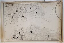
This rare(?) Section 7 street map from the NYC Board of Estimate & Apportionment includes the East River, Bronx River, Long Island Sound, Classon Pt, Fort Schuyler, Fort Totten, Whitestone and Throggs Neck (NO Bridges!!), Willetts Point, AND The St. Joseph Deaf & Dumb Asylum . . . .
Dimensions: 18.75\"H × 27.75\"L
Created in 1916, this single map is a fascinating piece of history that showcases various historical details of the region at that time. It is NOT nearly in mint condition; it IS a fascinating rustic glimpse of the layout of this portion of the Bronx 100 years ago.
This lot includes one (1) map, titled \"Area District Map Section 7\". It is well-worn, with tremendous Character, after more than a century of guiding New Yorkers to their destinations!
●Maps of seven (7) other Sections of NYC are also available.
These maps are perfect for collectors of historical memorabilia, as well as those interested in creating their own custom maps. They are a great addition to any collection and are sure to be conversation starters. Don\'t miss out on the opportunity to own these unique pieces of history!
7NYC Map—Bronx River/East River/Classon Pt/Ft. Schuyler/Throggs Neck/Whitestone $35.00

Mint 1966 NYC New York Subway Elevated Map. Brooklyn Manhattan Queens Bronx $69.00

Maps Of New York City Subway Street Map NYC Manhattan Queens Bronx Brooklyn $23.99

Giant 1914 Rare 18x36 New York City + Bronx Brooklyn NYC MAP $99.99

NEW YORK CITY: NYC. Lower Manhattan. Queens Bronx Brooklyn Richmond, 1920 map $50.00

New York City Manhattan Brooklyn Bronx Queens Staten Island Texaco map 1971 $12.99
RARE ca. NYC New York City + Brooklyn NYC IRT Bronx Queens SUBWAY map 7.5x11.5 $149.99

ORIG 1915? NYC Subway E163 St Brook Av Bronx New York Central & Harlem RR MAP $69.99
|


