|

On eBay Now...
6832 iv - MAP - Cam Ranh Bay Airfield - December 1969 - Cam Lâm - Vietnam War For Sale

When you click on links to various merchants on this site and make a purchase, this can result in this site earning a commission. Affiliate programs and affiliations include, but are not limited to, the eBay Partner Network.

6832 iv - MAP - Cam Ranh Bay Airfield - December 1969 - Cam Lâm - Vietnam War:
$299.99
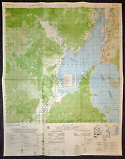
Vietnam War - US Military Map - December 19691969 - Cam Lâm - Vịnh Cam Ranh (Cam Ranh Bay) - Sân Bay Cam Ranh (Cam Ranh Airport) - Cam Ranh Bay Military Base - Nui Dat - Nui Ke - Cam Linh - Khanh Ho - Ninh Thuan - Cam Tho - Du Long - December 1969 US Military MapUS MILITARY MAP - Very Rare
Vietnam War MAP - Measures - 29 x 22.5 inches ( 74 x 59 cms )
Cam Ranh Bay Air Base, located on the southeastern coast of Vietnam, has a rich history dating back to ancient times when it was used as a sheltered harbor. However, its development into a major military installation began during the Vietnam War era. In the early 1960s, the United States recognized the strategic importance of Cam Ranh Bay and negotiated with the South Vietnamese government to establish a military presence there. Construction of the air base began in earnest in 1965, with the US military investing heavily in infrastructure and facilities to support its operations. By 1966, Cam Ranh Bay had become one of the largest and busiest air bases in the world, serving as a major hub for US military aircraft and troops. It housed various units, including the US Air Force, Navy, and Army, as well as South Vietnamese and allied forces. The air base played a crucial role in supporting US military operations during the Vietnam War, serving as a logistics hub, troop staging area, and aircraft maintenance facility. It also served as a key transit point for troops and supplies en route to other parts of Vietnam and Southeast Asia. After the Vietnam War ended in 1975, Cam Ranh Bay remained under Vietnamese control. It continued to be used as a military installation by the Vietnamese government, albeit on a smaller scale. In recent years, the Vietnamese government has undertaken efforts to develop the area into a commercial port and tourist destination, capitalizing on its natural beauty and strategic location.
6832 iv - MAP - Cam Ranh Bay Airfield - December 1969 - Cam Lâm - Vietnam War $224.99
|


