|

On eBay Now...
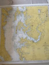
1967 Chesapeake Bay Map / Chart 1225, Cove Point To Sandy Point, C&GS, 39”x36” For Sale

When you click on links to various merchants on this site and make a purchase, this can result in this site earning a commission. Affiliate programs and affiliations include, but are not limited to, the eBay Partner Network.

1967 Chesapeake Bay Map / Chart 1225, Cove Point To Sandy Point, C&GS, 39”x36”:
$29.99
1967 Chesapeake Bay/ Chart 1225, Cove Point To Sandy Point, C&GS Chart 1225
Item is in very good condition with minimal signs of wear. Measures 39” x 36”. Please refer to the photos. The item pictured is the item you will receive.
Will be shipped rolled in a tube.
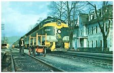
Chesapeake & Ohio Railroad Train # 4 Alderson West Virginia March 11 1967 $4.99

Vintage 1967 Chesapeake and Ohio Railway Chessie Calendar in Unused Condition $14.99
1967 Chesapeake Bay Map / Chart 1225, Cove Point To Sandy Point, C&GS, 39”x36” $29.99
MARCH 1967 CHESAPEAKE & OHIO C&O ACCIDENT REPORT #4117 FIRE CREEK WEST VIRGINIA $20.00

Original 35mm Kodachrome Slide Chesapeake & Ohio Reading Railroad Train 1967 $20.00

1967 CHESAPEAKE BAY BRIDGE TUNNEL OCEAN HIWAY PHOTO CONTEST BROCHURE $20.00
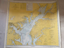
1967 Chesapeake Bay/ Chart 1226, Sandy Point To Susquehanna River C&GS, 39”x36” $29.99

C&GS Navigational Chart 550 Chesapeake Bay Eastern Bay-South River Jan 1967 $27.96
|


