|

On eBay Now...
1850s Map Central Portion United States Showing Lines Proposed Pacific Railroads For Sale

When you click on links to various merchants on this site and make a purchase, this can result in this site earning a commission. Affiliate programs and affiliations include, but are not limited to, the eBay Partner Network.

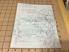
1850s Map Central Portion United States Showing Lines Proposed Pacific Railroads:
$625.00
Found this map in a trunk all folded up with a bunch of 1800\'s paper letters etc. I found a picture of this map on goggle in the Library Of Congress when I typed in map of proposed Pacific Railroads. I would suggest doing the same because there pictures are better than mine and this is the exact map except for the colored portions and IDS of the railroads which probably makes mine a little older. This sight will give you all the information on this map. They said it was made in New York 185?. Measures approx. 31 3/4\" x 8 3/4\". There are no holes in the map. It does have crease marks from being folded up for years. There is some slight yellowing down in some of the creases. There are a few wrinkles on the border where it had some storage folds from other items being up against it. On one of those border wrinkles are two 1/8\" long tears, nothing major. Made of very thin paper and should be properly framed and mounted for display. I could not find another one of these maps in my research and I would call it a rare map but I\'m sure you experts know. Email me with any questions. Oil City Merchants Florence Colorado.

1850s Map Central Portion United States Showing Lines Proposed Pacific Railroads $625.00

Map of the 1850s San Antonio to El Paso Routes. Printed 1996 Fletcher-Boeseh Col $13.99

1850s Vergennes Vermont City Town Map Old Vintage History Wall Poster Repro $14.99

1850s NorthEast Railroad Map: Great Western Railway - 24x48 $28.95

vintage Original New Hampshire small MAP, and info from 1850's or so $90.74

1850s Soho Tribeca Hudson Street New York City Manhattan Hand Drawn Map $399.99
original Hand Drawn Map of Pennsylvania, New York - in pencil - circa 1850's $70.20
Antique 1850 Map of the Macomb's Purchase in New York, 13.5 x 15.5". $49.95
|


