|

On eBay Now...
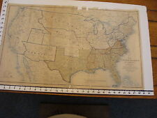
1891 Civil War Map United States Military Western Territories - Dec 31, 1862 For Sale

When you click on links to various merchants on this site and make a purchase, this can result in this site earning a commission. Affiliate programs and affiliations include, but are not limited to, the eBay Partner Network.

1891 Civil War Map United States Military Western Territories - Dec 31, 1862:
$200.00
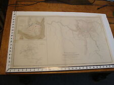
Lake Erie Maps & Printsstore An Original Antique Map: Not a Modern Reproduction! Plate CLXVI Atlas to Accompany the Official Records of the Union and Confederate Armies Currently Listing Many Civil War Maps Excellent Condition! Tittle: Map of the United States of America Showing the Boundaries of the Union and Confederate Geographical Divisions and Departments, Dec. 31, 1862 Description. The map shows the early division between the Union and the Confederate states at the beginning of Civil War. There is also a lot of historical detail in the Western Territories showing the Pony Express Routes, Santa Fe Trail and other mail and stagecoach routes. The various War Departments are in bold ouline with the Headquarters identified, as well as a lot of Forts shown. Early territorial boundaries including a very large Dakota Territory, an elongated Nebraska and New Mexico, Idaho as part of Washington, Oklahoma as Indian Territory and other border anomalies. It is an original antique map from theAtlas to Accompany the Official Records of the Union and Confederate Armies, published by the Secretary of War, (Washington: Government Printing Office, 1891-1895), undoubtedly the most complete set of accurate maps of the Civil War ever published. The title of the atlas appears in the top left margin and plate number in the upper right. A copy of the title page is includedwith all the publishing details for authenticity. The atlas was published in a very limited contextto bedistributed to government officials and libraries and by subscription to individuals, but was primarily put together to accompany theOfficial Recordsfor the US government and Congress to use as a reference for assessing the Civil War. Size:The printed area between the neat lines measures approximately 16 by27 inches on a pagemeasuring approximately18 by29 inches with plenty of margin all around for framing. It is a full double page sheet with a centerfold as issued. Condition:The map is in Excellent condition with only a hint of tonal aging.They don\'t get much better than this. Pics are of the actual map. Payment Details:We accept most major credit cards through Paypal and . Please ask if you have any questions about payment. International and New buyers are welcomed and encouraged. Payment is expected within 7 days, after which Nonpaying buyers will be reported to to recoup our listing fees. Save on Shipping:We only charge one shipping fee based on the largest map or print with multiple items shipped along with it for no extra costs. Purchase 5 or more maps or prints and receive Free First Class shipping in USA or First Class International elsewhere in the world, although registration may be required on shipments of high value. International Customs and VAT Fees:It is the responsibility of the buyer to pay all Customs Taxes, VAT or other fees that may be due upon arrival. These fees vary greatly from country to country and policy is that the buyer is responsible for their country\'s taxes and fees. Please consult your country\'s Customs Regulations for more details on your country, printed matter is duty free in many countries.We declare the full purchase value as required by law.Delays by Customs: Although most items arrive at their destination very quickly, we have no control over how long it takes an item to move through Customs, which can be held for up to six weeks in rare cases. Satisfaction Guaranteed:We stand fully behind our products and offer a full refund minus shipping with no questions asked.
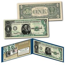
1891 Edwin STANTON Civil War Treasury One-Dollar Banknote designed on UNC New $1 $12.95
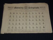
1891 MAY 30 MORNING TELEGRAPH NEWSPAPER - CIVIL WAR VOLUNTEERS - NP 2151Y $90.00
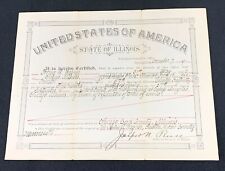
1891 State Of Illinois Civil War Veteran Service Certificate $25.00
1891 Civil War Map 18" X 29": US Boundaries Union & Confederate June 30, 1863 $191.51
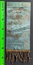
Antique 1891 Civil War 131st Regiment Reunion Lewisburg Pennsylvania Ribbon $95.00
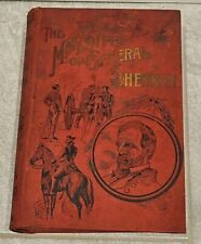
1891 MEMORIAL LIFE OF GENERAL WILLIAM TECUMSEH SHERMAN Chase Civil War $25.00
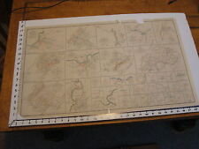
1891 Civil War Map 18" X 29": PLATE LXXXIV 36 maps VA repaired $205.88
1891 Civil War Map 18" X 29": CARNIFIX FERRY, GAULEY BRIDGE W.V., SOMERSET KY. $131.80
|


