|

On eBay Now...
1858 Map| Gillette\'s map of Oneida Co., New York : from actual surveys| Administ For Sale

When you click on links to various merchants on this site and make a purchase, this can result in this site earning a commission. Affiliate programs and affiliations include, but are not limited to, the eBay Partner Network.

1858 Map| Gillette\'s map of Oneida Co., New York : from actual surveys| Administ:
$34.99
Map Size: 24 inches x 24 inches | Fits 24x24 size frame | Frame not included | Archival Quality Reproduction | 1858 Map|Title: Gillette\'s map of Oneida Co., New York : from actual surveys|Subject: Administrative and Political Divisions|Cadastral Cities and Towns|Landowners|New York State|Oneida County|Oneida County N.Y|Real Property|Rome|Rome N.Y|Utica|Utica N.Y|Villages|Wall Maps Notes: County cadastral wall map showing towns (townships), numbered town survey divisions, irregular rural property tracts, rural buildings, and rural householders\' names. The Utica and Rome city insets show individual property lots and individual buildings. Hand colored (watercolor) to emphasize town and city boundaries. \"Entered according to Act of Congress in the year 1858 by Robert Pearsall Smith in ... the Eastern District of Pennsylvania.\" Originally printed on 6 sheets (later conjoined to form 2 sheets [northern/southern] on cloth backing).Each Map is Hand Printed in our StudioFine Art Matte Paper (230g, 14mil) that maintains vivid colors and faithfulness to the original map.Archival inks guaranteed not to fade for 200+ yearsYour map will be shipped in a protective tube via first class mail
Powered by SixBit\'s eCommerce Solution
Original 1858 Lithograph Map Potomac River Region Wash DC,Aqueduct, Arc Mounted $200.00

1858 Map of Northumberland County, Pa | Actual Survey Map | Pennsylvania Wall Ar $33.99

1858 Map| Map of Orange County, Vermont| Cadastral Landowners|Orange County|Oran $34.99

1858 Map| Map of Butler County, Pennsylvania| Butler County|Landowners|Pennsylva $34.99
Harper's Weekly 7/17/1858 James Monroe's remains exhumed / Gold Counties map $24.99
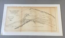
Map of 1858 Military Reconnaissance FORT DALLES OREGON via FORT WALLA WALLA $79.95

1858 Map| Colton's Kansas and Nebraska| Kansas|Nebraska|United States Map Size: $34.99

1858 Map| Map of the county of Berkshire, Massachusetts| Berkshire County|Berksh $34.99
|


