|

On eBay Now...
1856 Map | National Political Map of the United States | Administrative and Poli For Sale

When you click on links to various merchants on this site and make a purchase, this can result in this site earning a commission. Affiliate programs and affiliations include, but are not limited to, the eBay Partner Network.

1856 Map | National Political Map of the United States | Administrative and Poli:
$33.99
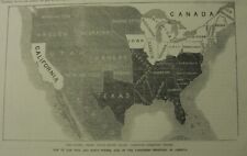
Map size: 20 inches x 24 inches | Fits 20x24 size frame (or 20x24 Mat Opening) | Frame not included | Archival quality reproduction1856 Map | National political map of the United States. Shows free states, slave states, and the territory open to slavery or freedom by the repeal of the Missouri Compromise. \"Entered according to Act of Congress in the year 1856, by A. Ranney, in the Clerk\'s Office of the District Court of the United States in and for the Southern District of New York.\" Prime meridians: Greenwich and Washington, D.C. Includes text, statistics from the 1850 census, table of 1852 election results, table of Presidents and Vice Presidents, political diagram, and 6 portraits.
Powered by SixBit\'s eCommerce Solution
1856 - pre-Civil War "MAP OF THE FREE AND SLAVE STATES, and Unsettled Territory" $34.95
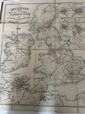
Bradshaw's Railroad Map of Britain & Ireland 1856 Folding Edition, Colored 24x28 $149.99

1856 Map of 17 & 19 Minor Street, Philadelphia Map of Sullivan County, New York $34.99

1856 Map| Barker's map of Washington County, Pennsylvania : from actual surveys| $34.99

1856 Map New York|New York|Plan of the city of New York Mangin-Goerck plan Facsi $34.99

1856 Map| Barker's map of Washington County, Pennsylvania : from actual surveys| $34.99

1856 Map| Map of the world shewing the extent and direction of the wind and the $34.99
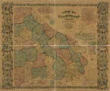
1856 Map| Barker's map of Washington County, Pennsylvania : from actual surveys| $34.99
|


