|

On eBay Now...
1827 Map| Map of the United States and the provinces of upper & lower Canada, Ne For Sale

When you click on links to various merchants on this site and make a purchase, this can result in this site earning a commission. Affiliate programs and affiliations include, but are not limited to, the eBay Partner Network.

1827 Map| Map of the United States and the provinces of upper & lower Canada, Ne:
$34.99
Map Size: 16 inches x 24 inches | Fits 16x24 size frame | Frame not included | Archival Quality Reproduction | 1827 Map|Title: Map of the United States and the provinces of upper & lower Canada, New Brunswick, and Nova Scotia|Subject: Canada|United States Notes: Includes insets \"A general map of North America\" and \"The continuation of East Florida on the same scale\". Each sheet was sectioned into 21 piecesEach Map is Hand Printed in our StudioFine Art Matte Paper (230g, 14mil) that maintains vivid colors and faithfulness to the original map.Archival inks guaranteed not to fade for 200+ yearsYour map will be shipped in a protective tube via first class mail
Powered by SixBit\'s eCommerce Solution
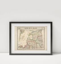
1827 Map of Estonia|Partie, Russie. Europe 9|Baltic Sea Region - Partie de la Ru $34.99
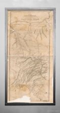
1827 Map| Map of the country embracing the several routes examined with a view t $34.99

1827 Map| Compendious chart exhibiting, at one view, the names of about thirteen $34.99
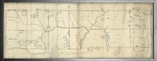
1827 Map| A copy of ... the fourth and fifth ranges of townships in the Kennebec $34.99

1827 Map| Map of the country embracing the several routes examined with a view t $34.99
1827 Map| Map of the country embracing the several routes examined with a view t $34.99
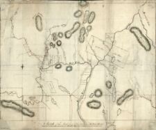
1827 Map| A sketch of the north part of the Kennebec Million Acres| Kennebec Riv $34.99

1827 Map| The harbour of New York| New Jersey|New York State|New York Harbor|New $34.99
|


