|

On eBay Now...
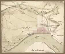
1778 Map| Sketch of the road from Paulus Hook and Hobocken to New Bridge| Hudson For Sale

When you click on links to various merchants on this site and make a purchase, this can result in this site earning a commission. Affiliate programs and affiliations include, but are not limited to, the eBay Partner Network.

1778 Map| Sketch of the road from Paulus Hook and Hobocken to New Bridge| Hudson:
$34.99
Map Size: 20 inches x 24 inches | Fits 20x24 size frame | Frame not included | Archival Quality Reproduction | 1778 Map|Title: Sketch of the road from Paulus Hook and Hobocken to New Bridge|Subject: Hudson County|Manuscript New Jersey|Paulus Hook Region|Roads|United States Notes: Scale ca. 1:24,000; 800 paces to an in. Manuscript, pen-and-ink and watercolor. Has watermarks. Oriented with north toward the upper left. Relief shown pictorially and by shading. Authorship attributed to B. Morgan and J. Hills in the table of contents of the collection. Includes note Fort Constitution \"Evacuated by the rebels, 18th Novr. 1776.\" Accompanied by Hills map collection title page and table of contents.Each Map is Hand Printed in our StudioFine Art Matte Paper (230g, 14mil) that maintains vivid colors and faithfulness to the original map.Archival inks guaranteed not to fade for 200+ yearsYour map will be shipped in a protective tube via first class mail
Powered by SixBit\'s eCommerce Solution

1778 Map| The Province of New Jersey, divided into East and West, commonly calle $34.99

1778 Map Township of Tredyffrin British camp at Trudruffrin from the 18th. to th $34.99

1778 Map| Buildings, Structures, Etc|Charleston|Charleston S.C|Charleston Harbor $34.99

Hawaii The Sandwich Islands 1778 baseball ball grographic map c45207 $16.00

1778 Map| Defenses|Early Manuscript Newport Region|Newport Region R.I|Rhode Isla $34.99
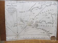
Map of the Cruise of the King's Fleet 1778 American Revolutionary War $35.00

1778 Map of Pensacola | Survey Map | Vintage Pensacola Florida Map Reproduction $34.99
1778 Map| Philadelphia and vicinity. Military| Early Fortification|Manuscript Pe $34.99
|


