|

On eBay Now...
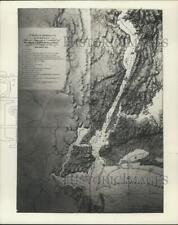
1777 Map of Rhode Island | Bristol | Narragansett Bay | Topographical Chart | Rh For Sale

When you click on links to various merchants on this site and make a purchase, this can result in this site earning a commission. Affiliate programs and affiliations include, but are not limited to, the eBay Partner Network.

1777 Map of Rhode Island | Bristol | Narragansett Bay | Topographical Chart | Rh:
$34.99
Map size: 16 inches x 2 feet (40.64cm x 60.96cm) | Ready to frame in standard size frame (16x24) | Frame not included | Archival quality reproduction1777 Map Rhode Island | Bristol | Narragansett Bay A topographical chart of the bay of Narraganset in the province of New England: with all the isles contained therein, among which Rhode Island and Connecticut have been particularly surveyed ; showing the true position & bearings of the banks, shoals, rocks &c. as likewise the soundings ; to which have been added the several works & batteries raised by the Americans ; taken by order of the principal farmers on Rhode Island.
Powered by SixBit's eCommerce Solution

1777 Map of Battle of Brandywine | September 11, 1777 | Chadds Ford Region | Pen $33.99

1777 Map of Battle of Brandywine | September 11, 1777 | Chadds Ford Region | Pen $34.99

Chinese Celestial Map 1777 Antique Historic Map Copy 12.5 x 16.5" $19.95
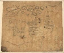
Press Photo 1777 map of Sandy Hook & Haverstraw Bay - sia08008 $16.88
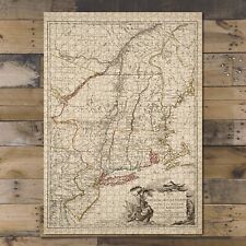
1000 pcs puzzle|1777 Map Northeastern United States Carte du the?atre $37.50

1777 Map New Jersey A New and accurate of the present seat of war in North Ameri $34.99
1777 Map| Essex County|Essex County N.J|History, Manuscript|New Jersey|Revolutio $34.99

1777 Map| Draft of roads in New Jersey| Camden County|Camden County N.J|Gloucest $34.99
|


