|

On eBay Now...
1700 Map| Matanzas ... puerto situado en la vanda del nortte de la Isla de Cuba For Sale

When you click on links to various merchants on this site and make a purchase, this can result in this site earning a commission. Affiliate programs and affiliations include, but are not limited to, the eBay Partner Network.

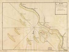
1700 Map| Matanzas ... puerto situado en la vanda del nortte de la Isla de Cuba:
$34.99
Map Size: 18 inches x 24 inches | Fits 18x24 size frame | Frame not included | Archival Quality Reproduction | 1700 Map|Title: Matanzas ... puerto situado en la vanda del nortte de la Isla de Cuba en 23 grados y 10 minutos de latittd. d. nortte y en 293 grados y 40 minutos de congd. desde la Isla de Tenerife, 20 leguas al ..|Subject: Coasts|Cuba|Manuscript Maps, Manuscript|Matanzas Bay|Matanzas Bay Cuba Notes: Depths shown by soundings. Prime meridian: Tenerife. Oriented with north toward the lower right. Watermark: Cluster of grapes[?]. Black and brown inks.Each Map is Hand Printed in our StudioFine Art Matte Paper (230g, 14mil) that maintains vivid colors and faithfulness to the original map.Archival inks guaranteed not to fade for 200+ yearsYour map will be shipped in a protective tube via first class mail
Powered by SixBit\'s eCommerce Solution

1700 Map| New map of the West Indies for the history of the British colonies| Ca $34.99
1700 Map of Veracruz Region | Nueba Verz-Cruz | Mexico | Veracruz Wall Art | Me $33.99

1700 Map of Cape Verde | Africa | Vintage Cape Verde Map | Cape Verde Map Reprod $33.99

1700 Map| Map showing coast of northern Yucatan Peninsula| Coasts|Gulf Coast|Gul $34.99
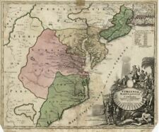
1700 Map| Virginia, Marylandia et Carolina in America septentrionali Brittannoru $34.99
1700s GERMAN MANUSCRIPT LAND SURVEY MAP, CULN, EAST PRUSSIA, Original (Poland) $149.99
1700 Map | Bahama Islands | West Indies | New Providence Island | Vintage Baha $33.99
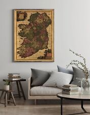
1700 Map of Ireland | Kingdom of Ireland | Ireland Map Reproduction | Ireland Wa $33.99
|


